-
You are here:
- Home

- About Myanmar

Information
Consular
Visa (references)
Scholar (references)
Country Profile
THE STATE FLAG
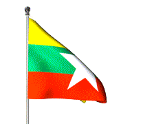
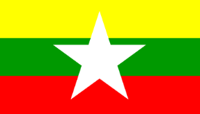 The Republic of the Union of Myanmar, adopted a new state flag on 21 October 2010. The new flag was introduced along with implementing changes to the country’s name, which were laid out in the 2008 Constitution. The design of the flag has three horizontal stripes of yellow, green and red with a five-pointed white star in the middle. The three colours of the stripes are meant to symbolise solidarity, peace and tranquility, and courage and
THE STATE SEAL
![]() The distinguishing features of the State Seal are as follows:-
The distinguishing features of the State Seal are as follows:-
- At the center of the State Seal is a pinion with fourteen equal-sized cogs on which the map of Myanmar is superimposed.The pinion and the map are encircled with two ears of paddy.
- The ears of paddy are flanked on each side by an artistic Myanmar Lion. The lion on the right side faces towards the right and the one on the left side faces towards the left.
- The words “The Union of Myanmar” are inscribed in Myanmar below the lions and the ears of paddy.
- At the top of the State Seal is a star with five vertices.
- Myanmar floral designs are etched on either side of the ears of paddy and the star.
Location
Myanmar is situated in Southeast Asia and is bordered on the north and northeast by China, on the east and southeast by Laos and Thailand, on the south by the Andaman Sea and the Bay of Bengal and on the west by Bangladesh and India. It is located between latitudes 09 32 N and 28 31 N and longitudes 92 10 E and 101 11 E.
Geography
The country covers an area of 677,000 square kilometres (261,228 square miles) ranging 936 kilometres (581 miles) from east to west and 2,051 kilometres (1,275 miles) from north to south, It is a land of hills and valleys and is rimmed in the north, east and west by mountain ranges forming a giant horseshoe. Enclosed within the mountaion barriers are the flat lands of Ayeyarwaddy, Chindwin and Sittaung River valleys where most of the country’s agricultural land and population are concentrated.
The length of contiguous frontier is 6,159 kilometres. The total length of Myanmar-Bangladesh boundary is 271 kilometres (168.7 miles). The total length of Myanmar-China boundary is 2,204 kilometres (1,370 miles); Myanmar-Thailand 2,107 kilometres (1,309.8 miles); Myanmar-India 1,338 kilometres (831.8 miles); and Myanmar-Laos 238 kilometres (147.9 miles).
Climate
As a whole, the location and topography of the country generated a diversity of climate conditions. Seasonal changes in the monsoon wind directions create summer, rainy and winter seasons. Extremes of temperature are rare. The directions of winds and depression bring rain, and although it is always heavy in the coastal areas during monsoon season, it seldom creates hardships. The Government is giving priority to the forest conservation and greening of nine arid districts in central Myanmar.
Flora and Fauna
Myanmar is endowed with a rich diversity of habitat types arising largely from its unusual ecological diversity. It is home to nearly 300 known mammal species, 300 reptiles and about 100 birds species, and a haven for about 7,000 species of plant life. Since Myanmar considers such a rich pool of bio diversity as an important national asset, the Government has drawn up strict regulations to protect its biological resources.
Population
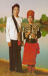
The Union of Myanmar is made up of 135 national races, of which the 8 major national races are Kachin, Kayah, Kayin, Chin, Bamar, Mon, Rakhine and Shan. Population of the country is estimated at 60 million and the population growth rate is 1.84 percent.
| 8 Major National Races | Composition of 135 Ethnic Groups |
| Kachin | 12 |
| Kayah | 9 |
| Kayin | 11 |
| Chin | 53 |
| Mon | 1 |
| Bamar | 9 |
| Rakhine | 7 |
| Shan | 33 |
| Total | 135 |
 Kachin National
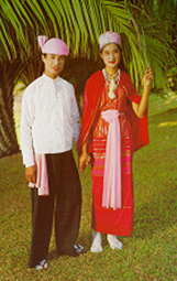 Kayah National
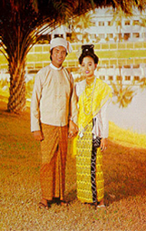 Kayin National
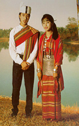 Chin National
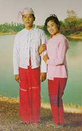 Mon National
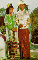 Bamar National
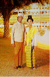 Rakhine National
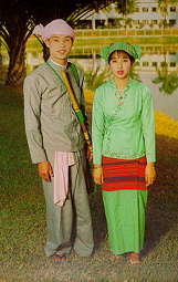 Shan National
The City of Nay Pyi Taw
Nay Pyi Taw is the administrative capital of the Union of Myanmar. Centrally located, it is 391 km from Yangon and 302 km from Mandalay, being easily accessible from all parts of the Union.
The environs of Nay Pyi Taw comprise (8) townships viz. ZeyarThiri, PohbbaThiri, UttaraThiri, ZabuThiri, DekinaThiri, Pyinmana, Lewe and Tatkone Townships. Nay Pyi Taw Airport is about 30 minutes from Nay Pyi Taw. All domestic carriers operate daily flights from Nay Pyi Taw to the commercial capital, Yangon, and the cultural capital Mandalay. There are flights via Nay Pyi Taw to tourist destinations such as Bagan, Heho, Sittwe, Myitkyina, Kyaing Tong and others.
Nay Pyi Taw Station is on the main Yangon-Mandalay rail line. It takes nine hours by train to get from Yangon to Naypyidaw. Nay Pyi Taw Airport, located 10 miles southeast of the city, is served by all domestic airlines. Air Bagan, Air Mandalay, Myanma Airways and Yangon Airways, with regular flights to Yangon and other cities across the country. A new highway from Yangon to Nay Pyi Taw has been opened recently and now the travelling time from Yangon to Nay Pyi Taw is only about 4 hours drive.
The City of Yangon
Currently, Yangon is the largest city, Commercial area and the gateway to Myanmar, was founded in 1755 by King AlaungPaya on the site of the small settlement called Dagon.
Yangon has a unique charm, with its old colonial buildings, tree-lined streets, bustling local markets and tranquil lakes.
There are famous golden pagodas that glisten amongst the trees and buildings like Shwedagon Pagoda, Sule Pagoda, Botataung Pagoda and Chaukhtatgyi Pagoda to name a few. The Shwedagon Pagoda, situated on a small hill with its spire rising to a height of 99.4 meters (326 ft.) is visible from all parts of the city and is considered one of the most magnificent monuments on earth. It’sstupa is covered with 8,000 solid gold plates and its tips set with diamonds, rubies, sapphires and topaz. A huge emerald in the middle of the stupa catches the first and last rays of the sun. Eight hairs of Lord Buddha and other relics are said to be enshrined in this pagoda.
People And Religion
Myanmar comprises eight major national ethnic races with some 135 ethnic groups. The major national races are Kachin, Kayin, Kayah, Chin, Mon, Bamar, Rakhine and Shan. The Bamar form the largest national race constituting 70% of the whole population. In the religious sector, 89.2% of the population is Buddhist, while Christianity, Islam, Hinduism, Judaism and Animism are also practised.
Historical Background
Archaelogical findings reveal that parts of Myanmar were inhibited some five thousand years ago. The ancestors of present-day Myanmars, the Pyus and the Mons established several kingdoms throughout the country from the 1st century A.D. to the 10th century A.D. From that early beginning, there are today a fascinating 135 nationalities who call Myanmar home.
Myanmar history dates back to the early 11th Century when King Anawrahta unified the country and founded the First Myanmar Empire in Bagan more than 20 years before the Norman Conquest of England in 1066(i.e. 1044 A.D.). The Bagan Empire encompassed the areas of the present day Myanmar and the entire Menam Valley in Thailand and lasted two centuries.
The Second Myanmar Empire was founded in mid-16th Century by King Bayinnaung(1551-1581). King Alaungpaya founded the last Myanmar Dynasty in 1752 and it was during the zenith of this Empire that the British moved into Myanmar. Like India, Myanmar became a British colony but only after three Anglo-Myanmar Wars in 1825, 1852, and 1885.
During the Second World War, Myanmar was occupied by the Japanese from 1942 till the return of the Allied Forces in 1945. Myanmar has become a sovereign independent state since 4th January 1948 after more than 100 years under the colonial administration.
States and Regions
Myanmar is Composed of Seven Regions and Seven States.
Seven Regions are :
- Ayeyarwady Region
- BagoRegion
- MagwayRegion
- Mandalay Region
- SagaingRegion
- TanintharyiRegion
- Yangon Region
Seven States are:
- Chin State
- Kachin State
- Kayah State
- Kayin State
- Mon State
- Rakhine State
- Shan State
Embassy Websites
Yangon Time
Bangkok Time
Contact Us
No. 110, Sathon nua Road, Bangkok, 10500, Thailand.
Phone: 0626283892, 022340320, 026379404
Fax: 02 236 6896, 02 233 7250
Email: [email protected]
Website: mebangkok.org